
Yose-juku
Get off the train at Sagami-ko Station and walk about 100 meters south to Koshu Kaido.

SAGAMIKO
When I looked back at the station from Koshu Kaido, I saw a cool SAGAMIKO sign, so I couldn’t resist taking a picture of it.

Magoyama
This mountain is Magoyama, and it looks like a patchwork of distinct vegetation. Did it happen naturally? Or was it artificially planted?

Marker for Jigenji Temple
I found the temple marker for Jigenji Temple!
The approach to the temple is a footbridge over the Chuo Expressway.
The north side of Sagami Lake is a cliff, with the mountains looming nearby. The Koshu Highway, the Chuo Expressway, and the Chuo Line all crisscross the narrow foothills between the lake and the valley.
The Chuo Expressway had to be converted to a pedestrian bridge because of the need to pinpoint this point where the approach to the road was.

Stairs to visit Yose Shrine
I found another similar staircase for a pedestrian bridge just to the left of it. This one is beyond the torii gate and is the stairs for visiting Yose Shrine.
Because of the number of steps, I didn’t climb it, but looking at the aerial photo, the two footbridges merge in the middle and seem to be quite wide. Probably, the pedestrian bridge is quite crowded during the New Year’s visit.
Many people may expect the Jigenji Temple to be of benefit in caring for their eyes, as they often overuse their eyes these days.

Chuo Expressway, Chuo Line and ordinary roads
In the upper right is the Chuo Expressway, and below is the Chuo Line running from the front to the tunnel at the back.
In between, a public road passes from the left to the right of the Chuo Expressway and back to the left again.
This is a cliff eroded by the water of Sagami Lake, and it would have been cheaper to take the long way around than to bury the cliff or use a bridge.
Incidentally, the Koshu Kaido I’m walking on once passes to the right of the Chuo Expressway, but it doesn’t come back immediately. It will be about 1 km before it intersects the Chuo Expressway again.

mountain road
Once you leave the main road, the road suddenly becomes mountainous.

Small bridge with remaining snow
Found a small bridge in the remaining snow!
There are a few footprints on it. I wondered if they were the footprints of people traveling along the Koshu Kaido, or the footprints of locals.
It was quite slippery, so I walked carefully step by step.

Remains of an Ichirizuka at Yosejuku
I found the remains of the Yosejuku’s ichirizuka (one-mile mound) as I came up from the valley.
Why is it that there are no mounds to be found in such an empty place that there is no need to take the trouble to clear the land? I wonder if the man-made mounds will return to flatness if they are not taken care of.

Sagami Lake and Katsuse Bridge
Sagami Lake can be seen clearly. The bridge on the right is Katsuse Bridge.

The Chuo Expressway passing through a cut
The Chuo Expressway passes through a cut. The money spent on this road is different from that of ordinary roads, which are hesitant to build a short bridge and have to make a detour.

A handwritten destination sign indicating the Yoshino-juku
There was a hand-written destination sign at a junction where it was difficult to tell whether to turn or not. I thankfully headed in the direction of Yoshino Inn.
Yoshino-juku

Near the Sagamiko IC branch of the Chuo Expressway
The Chuo Expressway, which I passed under earlier, is now crossed by a pedestrian bridge.
This is near the junction where the down lane splits into the Sagami-ko IC.

A view from the west end of Sagami Lake
This is a view from the west of Sagami-ko, looking toward the northeast where I had just walked.
The mountain on the right is the patchwork Sun Mountain, and there is a snow bridge in the valley coming down from there to the left, and an Ichirizuka uphill from the valley.

Yoshino-juku “Fujiya”
“Fujiya,” which used to be a travel agency in Yoshinojuku, has been turned into a local museum. I wanted to stop by there, of course. But it was already past 3:00 p.m. and the sun was setting, so I decided to give up this time.
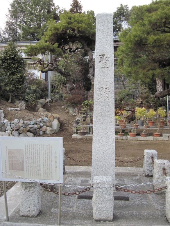
Yoshino Honjin Ruins
Facing Fujiya is the site of the Yoshino Main Camp. The reason why there is a stone monument that says “Holy Site” on it is probably because it was the residence of the Emperor Meiji. The five-story wooden building was destroyed by fire in 1896.

Sawai River
This river with a calm surface is the Sawai River. It flows from the direction of Sawai Station on the Ome Line, so I checked the map to see if there might be a connection. But it doesn’t seem to have anything to do with the river, since it has to cross the watershed three times.
Sekino-juku

Chuo Line and Chuo Expressway
At a point about 400 meters west of Fujino Station, cross the railroad tracks and exit to the north of the tracks.
The Fujino Station platform can be seen across the curved railroad tracks.
On your left is the Chuo Expressway.
Soon, the remains of the Sekino Main Camp appeared, but there was only a sign.
Uenohara-juku

Sakaigawa Bridge
The magnificent Sakai River Bridge appeared along the road.
As I tried to cross it without thinking, I saw the words “Kanagawa Prefecture” and “Sagamihara City” on the signboard on the other side of the river.
Huh? I thought I was walking through Sagamihara City now?

Signboards in Uenohara City
I looked up at the signboard in front of the bridge, and it said “Uenohara City, Yamanashi Prefecture.
Huh? When did I get into Yamanashi? I don’t understand.
After a little more walking, I came to a slightly higher place, and I could see the reason for all this.

A bridge across the border between Kanagawa and Yamanashi prefectures
Before I encountered the Sakaigawa Bridge, I had somehow crossed the bridge shown in the photo (name unknown).
The river flowing underneath is the Sakai River. It is a river that borders the prefecture. Sagamihara City is on the other side, and Uenohara City is in front. That’s why I entered Yamanashi Prefecture here.
The splendid Sakaigawa Bridge is located slightly upstream of the point where the Sakaigawa River joins the Sagami River.
Downstream of the river flowing under the Sakaigawa Bridge is the Sagami River, which differs from the name of the bridge. But the upper stream is called Katsura River, and the name of the river seems to change around here.
The border between prefectures goes from the Sakai River to the Sagami River, and then through the Sakai River Bridge to the Katsuragawa River. Ah, it’s complicated.

Ruins of Suwa Barrier Site
Climbing up the winding slope eroded by the Katsura River and the Sakai River, the ruins of the Suwa barrier appear.
Reading the signboard, you can vaguely understand that it had been in operation since 1707. But other than that, there are so many omissions that I don’t know what they are trying to tell us. In the first place, the stone pillar says “Site of Suwa Seki”, but the signboard says “Site of Suwa Banjo”, and the difference between the two is incomprehensible. Also, the number ” 2to 3shou 3gou” suddenly appears. I don’t know if it is the amount of rice harvested from the rice fields in the house, the annual tribute to be paid, or the amount of stones paid. In addition, there is a note that says, “Passage bill changed* but Kobotoke Sekisho (Komakino). If they didn’t change the bills here, it’s not a barrier, and I don’t think it’s necessary to explain the Kobotoke barrier here.

tsukaba Irizuka
After crossing the Chuo Line and the Chuo Expressway again, there is Hosou (smallpox) shinto shrine, and the hill behind the shrine is said to be the Tsukaba Ichirizuka. This hill is probably the one in this photo.
According to an old man, there used to be kaya trees planted on the hill. But now, boxwood? and shuro?
Isn’t shuro an invasive species? I hope they don’t plant it in the traditional Ichirizuka.
Today’s walk took me to the Shinmachi 2-chome intersection, and from there I walked about 1.2 km to Uenohara Station.
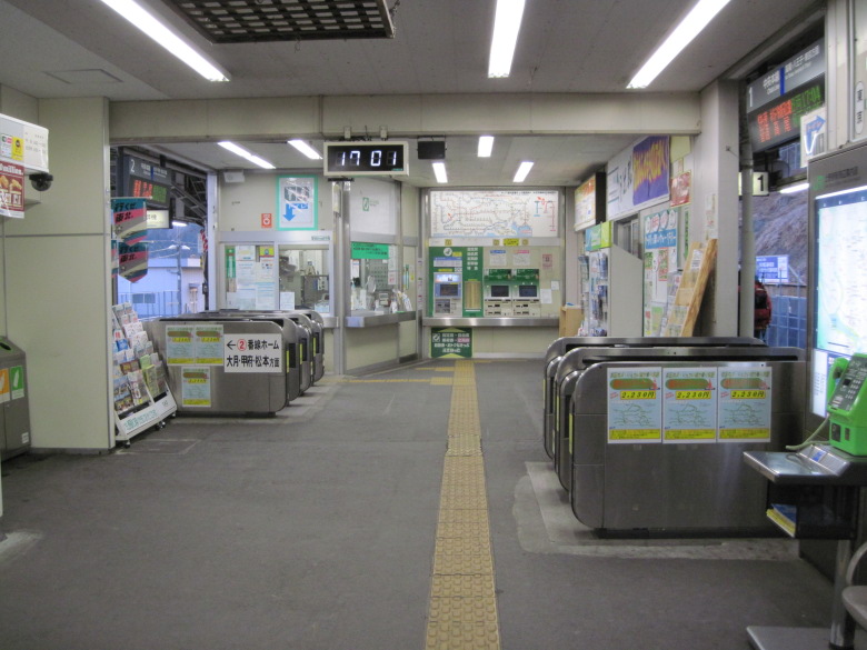
Uenohara Station
I was surprised when I walked into the station.
There is a station building in the middle of the platform, and automatic ticket gates on both sides, through which you enter the platform.
It’s a novel structure.
Walking data
Course: JR Chuo Line Sagami-ko -> Yose-juku -> Yoshino-juku -> Sekino-juku -> Uenohara-juku -> JR Chuo Line Uenohara Station
Distance: 13.2km
Time: 3h4m


コメント