During my walk, I found the Togo Shrine, so I paid a visit to it.
Gakushuin Women’s University Main Entrance

Ikebukuro Station
I got off at Ikebukuro.
Ikebukuro is a station with an average of more than 2.6 million passengers per day, so as expected, there were a lot of people there.

LABI1 Japan General Store
What used to be Mitsukoshi has been Yamada Denki for the past 10 years. It is now labeled as LABI1 Nihon Sohonten.
From here, head south on Meiji-dori.

Chitose-bashi Bridge
I found the Chitose-bashi bridge over a kilometer after I started walking.
Above is Mejiro-dori, and below is Meiji-dori.
Meiji-dori runs through a cut through the street, which is a strange sight as it is difficult to show naturally.

Takato Bridge
I crossed the Kanda River at Takato Bridge.
The water level in the Kanda River today was not too high.

Main gate of Gakushuin Women’s College,
This splendid gate is the main gate of Gakushuin Women’s College, an important cultural asset.
Today, it seems to be an open campus.
I once entered the gate during a university festival when this was Gakushuin Women’s Junior College. I remember the gate was black at that time.
There was a rumor that the guard would greet us with a “Gokigenyo (Good day)”, but I don’t even remember if he was there at that time. I wonder if they still say “Gokigenyo” today. I was on the other side of the road today, so I didn’t hear it.

Waseda University Nishi-Waseda Campus
Across Meiji-dori, on the other side of Gakushuin Women’s College, is the Nishi-Waseda campus of Waseda University. There’s a statue of Professor Shigenobu Okuma.

Meiji-dori Avenue with wide sidewalks
Meiji-dori Avenue seemed to be expanding, and the sidewalks were wider.

Shinjuku 6-chome Crossing
At the Shinjuku 6-chome intersection, you will come to a fork.
According to Google Maps, the road to the right is Meiji-dori, and the one to the left is Shiba-Shinjuku-Oji Line. But the road we’ve just come from, including the road we’re on, is Tokyo Route 305. I’m not sure what to call it, but it’s on the left.
Construction of underground tunnels and streets

Starting point of underground tunnel construction and street construction
At the intersection of Shinjuku 2-chome, I crossed the old Koshu Kaido highway and ended up a little further down the road. An underground tunnel will start here, and construction work was underway. The construction period is said to be from mid-March, 2008 to early October, 2019. It will be open to traffic in a little over two months.
The left side (east side) of the construction site is the Shinjuku Gyoen, so I decided to go around from the right side.

Intersection with underground tunnel construction site
On my way around, I intersected a construction site. It is an underground tunnel, so I guess the path I am walking on now will remain as it is.

View of the north (Shinjuku 2-chome) direction from the intersection
I looked north from the intersection point. There are steel plates on the ground, so it looks like they are opening up the road for construction.

View of the north (Sendagaya 5-chome) direction from the intersection
This is the view from the intersection looking south.
There is also a steel plate here.
The road that leads to it is Meiji-dori, which I just left.
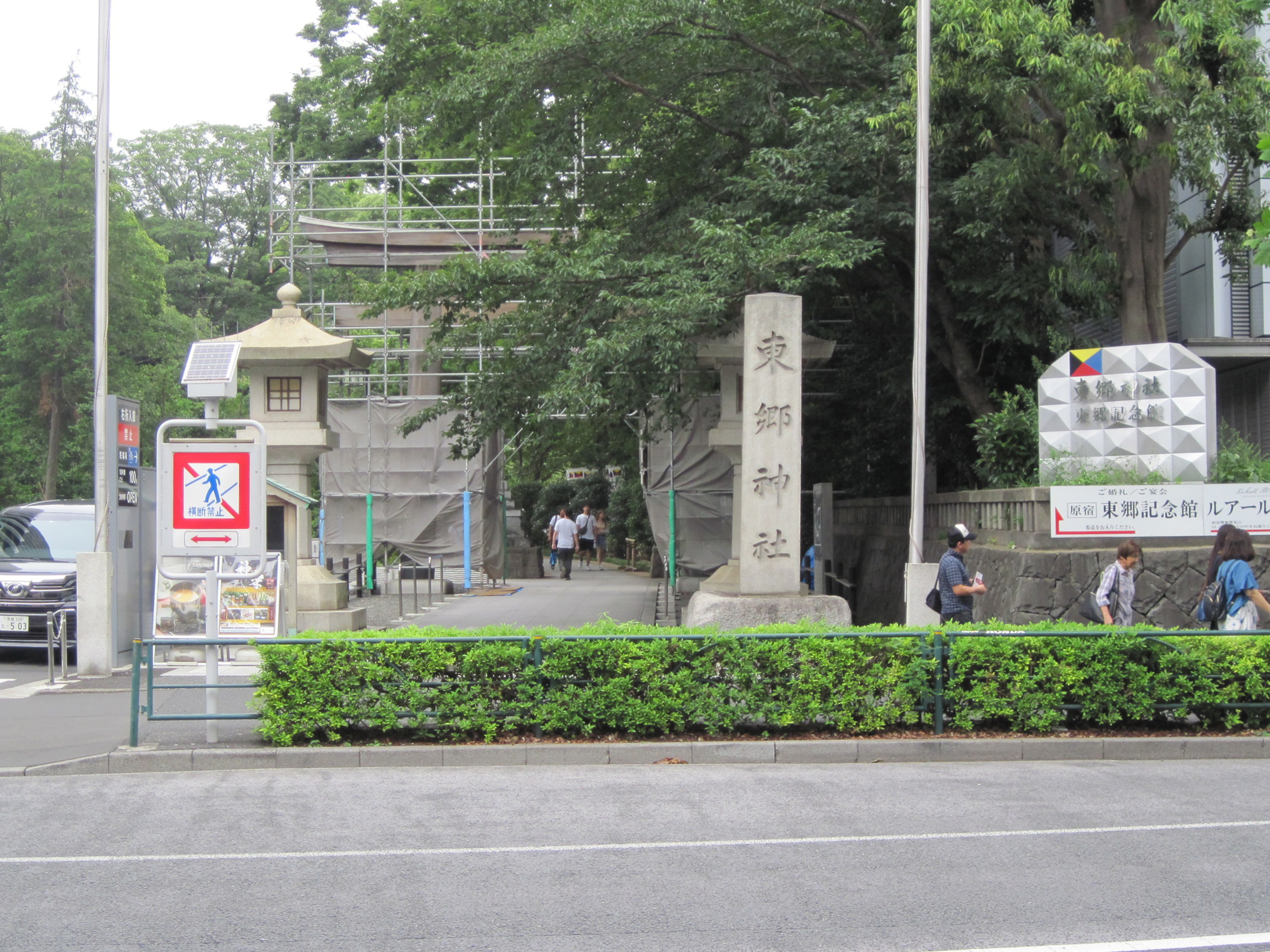
Togo Shrine
After returning to Meiji-dori and walking for a while…

Togo Shrine
I found the Togo Shrine!
I had heard of the shrine, but I didn’t know it was located along Meiji-dori. I’d heard of the shrine, but I didn’t know it was located along Meiji-dori. Having read “Saka no Ue no Kumo (Clouds on the Hill),” and being impressed by Admiral Togo, I decided to pay a visit.

Pond at Togo Shrine
There is a pond right after entering the precincts.
It looks familiar to me. “It was aired on “Ike no Mizu Zenbu Nuku Daisakusen (Pond Water Extraction Operation).” I looked it up and found that it was broadcast on June 24, 2018. That was almost a year ago. Is it safe to say that it’s still beautiful?

Togo Shrine Main Hall
This is the main shrine.
Two people who are going to get married are getting an explanation.
To the left is a Z flag.
The Z flag appeared in “Clouds on the Hill” during the Battle of the Sea of Japan during the Japanese-Russo War, but I didn’t understand why it was written so dramatically.
According to what I understood from my research and other sources today, the following is true.
Ships are equipped with 40 types of flags called international signal flags. Twenty-six of them are alphabetical. These flags can also have meanings in place of the alphabet. For example, a Z flag can be assigned to mean “tow me with a tugboat” or “I am in the middle of casting a net (if I am near a fishing ground)”.
At the time, the Japanese navy did not need to be informed of the nets, so I assigned it the meaning of “open the sealed orders.” When they saw the Z flag flying on the flagship Mikasa, they opened the order and found that it read, “The rise and fall of the Imperial State, this is one battle. Based on this, they made strenuous efforts in the battle, and as a result, they won.
By the way, I remembered that I went to Yokosuka to see the Mikasa just before the Great East Japan Earthquake.

Reference: Z flag on Mikasa (photo taken on March 5, 2011)
The Z flag is smaller than I expected. I guess people in the past had good eyesight.

Reference] View from the bridge (taken on March 5, 2011)
When I stand where Admiral Togo stood, I am immersed in a variety of moods.
Back to the main text.

Takeshita Street
Takeshita Street is right next to the Togo Shrine.
I didn’t expect it to be so close.
I’m not good with crowds, but today I’m going to walk along this Takeshita Street.

Harajuku Station
I could see Harajuku Station. After all, I don’t like streets with too many people.
Walking data
Course: JR Yamanote Line Ikebukuro Station -> Loop Route 5 (Ikebukuro Station East Exit North – Takeshita Exit) -> JR Yamanote Line Harajuku Station
Distance: 9.8km
Time: 2h43m

